<?xml version="1.0" encoding="utf-8"?><feed xmlns="http://www.w3.org/2005/Atom" xml:lang="en"><generator uri="https://jekyllrb.com/" version="3.10.0">Jekyll</generator><link href="https://f9xr.github.io/BharatByDay/atom.xml" rel="self" type="application/atom+xml" /><link href="https://f9xr.github.io/BharatByDay/" rel="alternate" type="text/html" hreflang="en" /><updated>2026-08-16T14:18:49+05:30</updated><id>https://f9xr.github.io/BharatByDay/atom.xml</id><title type="html">भारतByDay</title><subtitle>One unique spot in India to explore, every single day. भारतByDay uncovers offbeat India — hidden stepwells, forgotten valleys, and local culture that the guidebooks miss.</subtitle><author><name>F9XR Editorial Team</name></author><entry><title type="html">Chikmagalur: Karnataka’s Coffee Land Guide 2026</title><link href="https://f9xr.github.io/BharatByDay/chikmagalur-coffee-land-karnataka-guide" rel="alternate" type="text/html" title="Chikmagalur: Karnataka’s Coffee Land Guide 2026" /><published>2026-08-04T00:00:00+05:30</published><updated>2026-08-04T00:00:00+05:30</updated><id>https://f9xr.github.io/BharatByDay/chikmagalur-coffee-land-karnataka-guide</id><content type="html" xml:base="https://f9xr.github.io/BharatByDay/chikmagalur-coffee-land-karnataka-guide"><![CDATA[<p>If you’ve ever sipped a cup of South Indian filter coffee and wondered where those beans actually come from, chances are the answer traces back to a small hill town tucked into the Western Ghats. Chikmagalur isn’t just another weekend getaway on Karnataka’s tourist map. It’s the place where Indian coffee cultivation began, and it remains one of the country’s most important coffee-growing regions to this day.</p>

<p>Spread across rolling hills at an elevation of roughly 1,090 meters, Chikmagalur (often spelled Chikamagaluru) combines misty mornings, sprawling coffee estates, and dramatic peaks like Mullayanagiri, the highest point in Karnataka. For travelers, it’s a nature lover’s dream. For business owners, coffee producers, homestay operators, and local entrepreneurs, it’s also a growing economic hub that’s attracting attention from tourists, investors, and digital audiences alike.</p>

<p>In this guide, we’ll walk through what makes Chikmagalur special, why it holds such an important place in India’s coffee story, the best time to visit, top attractions, and practical information for anyone planning a trip or running a business in the region. Whether you’re a traveler, a local business owner, or someone researching the area for the first time, this article is built to answer the questions people are actually asking, on Google and on AI search tools alike.</p>

<h2 id="a-quick-snapshot-of-chikmagalur">A Quick Snapshot of Chikmagalur</h2>

<table>
  <thead>
    <tr>
      <th>Feature</th>
      <th>Details</th>
    </tr>
  </thead>
  <tbody>
    <tr>
      <td>Location</td>
      <td>Western Ghats, Karnataka, India</td>
    </tr>
    <tr>
      <td>Elevation</td>
      <td>Approx. 1,090 meters (3,576 ft)</td>
    </tr>
    <tr>
      <td>Known For</td>
      <td>Coffee cultivation, hill trekking, cool climate</td>
    </tr>
    <tr>
      <td>Highest Peak</td>
      <td>Mullayanagiri (1,930 meters)</td>
    </tr>
    <tr>
      <td>Best Time to Visit</td>
      <td>October to May</td>
    </tr>
    <tr>
      <td>Nearest Major City</td>
      <td>Mangaluru (about 100 km)</td>
    </tr>
    <tr>
      <td>Nearest Airport</td>
      <td>Mangalore International Airport / Kempegowda Airport, Bengaluru</td>
    </tr>
    <tr>
      <td>Ideal Trip Duration</td>
      <td>2 to 4 days</td>
    </tr>
    <tr>
      <td>Primary Industry</td>
      <td>Coffee, tourism, plantation agriculture</td>
    </tr>
  </tbody>
</table>

<h2 id="the-coffee-land-in-a-nutshell">The Coffee Land in a Nutshell</h2>

<p>Take a quick visual tour of Chikmagalur — the estates, the peaks, and the coffee culture that earned this region its “Coffee Land” title — in the presentation below from the F9XR Team.</p>

<iframe src="https://www.slideshare.net/slideshow/embed_code/key/ocYc0saMSm1vKc" width="100%" height="420" frameborder="0" marginwidth="0" marginheight="0" scrolling="no" style="border:1px solid #CCC; border-width:1px; margin-bottom:5px; display:block; max-width:100%;" allowfullscreen=""></iframe>

<div style="margin-bottom:5px">
  <strong><a href="https://www.slideshare.net/slideshow/chikmagalur-the-coffee-land-of-karnataka/288958888" title="chikmagalur-the-coffee-land-of-karnataka" target="_blank">chikmagalur-the-coffee-land-of-karnataka</a></strong> from <strong><a href="https://www.slideshare.net/F9XR" target="_blank">F9XR Team</a></strong>
</div>

<h2 id="the-birthplace-of-indian-coffee">The Birthplace of Indian Coffee</h2>

<p>Long before coffee culture became a global phenomenon, Chikmagalur was already growing beans. According to local legend, a Sufi saint named Baba Budan brought coffee seeds from Yemen and planted them in the hills that now bear his name, the Baba Budangiri range. That’s generally regarded as the starting point of coffee cultivation in India, and it happened right here.</p>

<p>Today, Chikmagalur district is one of Karnataka’s largest coffee-producing regions, alongside Kodagu (Coorg) and Hassan. Karnataka as a whole accounts for a significant share of India’s total coffee output, and Chikmagalur’s Arabica and Robusta plantations are a major part of that contribution. The region’s mix of altitude, rainfall, and shade-grown cultivation methods gives its coffee a distinct character that’s valued both domestically and in export markets.</p>

<p>For anyone running a café, roastery, or specialty coffee brand, understanding Chikmagalur’s role in the supply chain isn’t just trivia. It’s genuinely useful context when sourcing beans, building brand storytelling, or marketing a product as authentically Indian-grown coffee.</p>

<h3 id="why-the-climate-matters-for-coffee-growing">Why the Climate Matters for Coffee Growing</h3>

<p>Coffee, especially Arabica, is a fussy crop. It needs shade, consistent rainfall, well-drained soil, and a temperature range that doesn’t swing too wildly. Chikmagalur checks all these boxes:</p>

<ul>
  <li>Average annual rainfall between 2,500 mm and 3,500 mm in many estate areas</li>
  <li>Temperatures generally ranging from 15°C to 28°C through most of the year</li>
  <li>Rich, well-drained laterite soil ideal for plantation crops</li>
  <li>Natural forest cover that provides shade for Arabica plants</li>
</ul>

<p>This combination is exactly why coffee estates have thrived here for generations, and why the region continues to draw agricultural researchers, exporters, and coffee tourism ventures.</p>

<h2 id="top-things-to-see-and-do-in-chikmagalur">Top Things to See and Do in Chikmagalur</h2>

<p>While coffee is the headline attraction, Chikmagalur offers a lot more for travelers who want a full hill-station experience.</p>

<h3 id="1-mullayanagiri-peak">1. Mullayanagiri Peak</h3>

<p>As Karnataka’s highest peak, Mullayanagiri offers panoramic views of the Western Ghats. It’s a moderately easy trek, making it accessible for beginners, and the sunrise view from the top is often described by visitors as one of the best in South India. If you’re after a longer, wilder ridge trek with far fewer crowds, our <a href="/BharatByDay/dzuko-valley-the-flower-meadow">Dzüko Valley guide</a> covers a stunning meadow trek on the Nagaland–Manipur border.</p>

<p><img src="https://cdn.s3waas.gov.in/s367d96d458abdef21792e6d8e590244e7/uploads/2017/03/2018080635.jpg" alt="Mullayanagiri Peak, the highest point in Karnataka" loading="lazy" decoding="async" />
<em>Mullayanagiri Peak stands at 1,930 metres, the highest point in Karnataka.</em></p>

<p><img src="https://cdn.s3waas.gov.in/s367d96d458abdef21792e6d8e590244e7/uploads/2017/03/2018080678-1.jpg" alt="Trekking trail towards the Mullayanagiri summit" loading="lazy" decoding="async" />
<em>The summit trail is a moderately easy trek that rewards you with sunrise views over the Western Ghats.</em></p>

<p><img src="https://hblimg.mmtcdn.com/content/hubble/img/desttvimg/mmt/destination/t_trp/m_Chikmagalur_tv_destination_img_1_l_720_1079.jpg?im=Resize=(750,399)" alt="Chikmagalur's rolling hill landscape" loading="lazy" decoding="async" />
<em>Beyond Mullayanagiri, Chikmagalur’s misty hills hide coffee estates, waterfalls, and quiet village trails.</em></p>

<h3 id="2-baba-budangiri-range">2. Baba Budangiri Range</h3>

<p>Beyond its historical significance as the origin point of Indian coffee, this range is also home to the Guru Dattatreya Peetha shrine, drawing both trekkers and pilgrims.</p>

<h3 id="3-coffee-estate-tours">3. Coffee Estate Tours</h3>

<p>Several estates around Chikmagalur now offer guided tours where visitors can walk through plantations, learn about the roasting process, and sample fresh, estate-grown coffee. This has become a strong niche within Karnataka’s tourism sector, blending agritourism with hospitality.</p>

<h3 id="4-hebbe-falls">4. Hebbe Falls</h3>

<p>A scenic waterfall located inside a private coffee estate, Hebbe Falls requires a jeep ride through dense forest, which is part of the appeal for adventure-seeking visitors.</p>

<h3 id="5-kemmangundi">5. Kemmangundi</h3>

<p>A former summer retreat of the Mysore royal family, Kemmangundi offers cooler temperatures, well-maintained gardens, and views that rival many better-known hill stations.</p>

<h3 id="6-bhadra-wildlife-sanctuary">6. Bhadra Wildlife Sanctuary</h3>

<p>Home to tigers, elephants, and a wide range of bird species, this sanctuary is ideal for wildlife enthusiasts and adds an eco-tourism dimension to the region.</p>

<h2 id="best-time-to-visit-chikmagalur">Best Time to Visit Chikmagalur</h2>

<p>Chikmagalur is a year-round destination, but the experience changes significantly with the seasons.</p>

<h3 id="october-to-february-peak-season">October to February (Peak Season)</h3>

<p>This is generally considered the best window. Temperatures stay cool and comfortable, skies are clear, and it’s an ideal time for trekking and estate visits.</p>

<h3 id="march-to-may-summer">March to May (Summer)</h3>

<p>Warmer than winter but still cooler than most of Karnataka’s plains. This period is popular for those wanting a break from the heat elsewhere in the state.</p>

<h3 id="june-to-september-monsoon">June to September (Monsoon)</h3>

<p>The region turns lush and green, waterfalls are at their fullest, and coffee estates look stunning. However, heavy rainfall can make trekking and road travel more challenging, so it’s better suited to travelers who don’t mind getting a little wet.</p>

<h2 id="how-to-reach-chikmagalur">How to Reach Chikmagalur</h2>

<p><strong>By Air:</strong> The nearest airport is Mangalore International Airport, roughly 100 km away. Kempegowda International Airport in Bengaluru, around 245 km away, is another common option with more flight connectivity.</p>

<p><strong>By Rail:</strong> Kadur Junction, about 40 km from Chikmagalur town, is the closest major railway station with good connections to Bengaluru and other cities.</p>

<p><strong>By Road:</strong> Chikmagalur is well connected by state highways, with regular bus services from Bengaluru, Mysuru, and Mangaluru. The drive from Bengaluru typically takes around 5 to 6 hours depending on traffic.</p>

<h2 id="chikmagalurs-growing-economic-and-business-landscape">Chikmagalur’s Growing Economic and Business Landscape</h2>

<p>While coffee remains the backbone of the local economy, tourism has grown into a major second pillar. Homestays, resorts, adventure tourism operators, and local food businesses have expanded steadily over the past decade, particularly as travelers from Bengaluru, Chennai, and Hyderabad look for accessible weekend and short-break destinations.</p>

<p>This growth brings real opportunity, but also real competition. For small and medium business owners in Chikmagalur, whether you run a homestay, a coffee brand, a travel agency, or a local eatery, being discoverable online has become just as important as your physical location. A growing share of travelers now research destinations using search engines and increasingly AI-based tools before making a booking decision. That means having accurate, well-structured information about your business online isn’t optional anymore.</p>

<h3 id="practical-tips-for-local-business-owners">Practical Tips for Local Business Owners</h3>

<p>If you run a business in or around Chikmagalur, here are a few actionable steps worth prioritizing:</p>

<ol>
  <li><strong>Claim and optimize your Google Business Profile.</strong> Make sure your address, hours, photos, and contact details are accurate and updated regularly.</li>
  <li><strong>Use location-specific keywords.</strong> Terms like “Chikmagalur homestay,” “coffee estate stay Chikmagalur,” or “Mullayanagiri trek guide” help you show up for the searches people are actually making.</li>
  <li><strong>Collect and respond to reviews.</strong> Genuine customer reviews build trust, and responding to them signals active, reliable management.</li>
  <li><strong>Invest in a mobile-friendly website.</strong> A large share of travel research happens on phones, so a slow or clunky site can cost you bookings.</li>
  <li><strong>Highlight your unique story.</strong> If you’re a coffee estate, share your growing process. If you’re a homestay, share what makes your location or hospitality distinct. Authentic storytelling performs well with both human visitors and AI-driven search tools that summarize content for users.</li>
  <li><strong>Keep information consistent across platforms.</strong> Your business name, address, and phone number should match across your website, social media, and directory listings.</li>
</ol>

<p>These steps matter more than ever now that AI search engines like ChatGPT, Gemini, and Perplexity increasingly pull structured, trustworthy information to answer user queries directly, sometimes without the user ever clicking through to a website. Businesses with clear, well-organized digital content are simply more likely to get referenced.</p>

<h2 id="coffee-culture-beyond-the-estates">Coffee Culture Beyond the Estates</h2>

<p>It’s worth noting that Chikmagalur’s identity as “Coffee Land” isn’t just about agriculture. It has shaped local cuisine, festivals, and even architecture. Many homestays and resorts are built on or near working coffee estates, giving visitors a genuine sense of plantation life rather than a manufactured tourist experience.</p>

<p>Local coffee festivals and estate-stay experiences have also helped position Chikmagalur alongside Coorg as one of South India’s leading coffee tourism destinations. For entrepreneurs, this opens doors for niche businesses: coffee tasting experiences, farm-to-cup cafés, specialty roasteries, and even coffee-themed retail products aimed at tourists looking for authentic souvenirs.</p>

<h2 id="key-takeaways">Key Takeaways</h2>

<ul>
  <li>Chikmagalur is widely regarded as the birthplace of coffee cultivation in India, with roots tracing back to Baba Budangiri.</li>
  <li>The region’s elevation, rainfall, and soil make it naturally suited for Arabica and Robusta coffee farming.</li>
  <li>Major attractions include Mullayanagiri Peak, Baba Budangiri, Hebbe Falls, Kemmangundi, and Bhadra Wildlife Sanctuary.</li>
  <li>October to May is generally the best time to visit, with October to February being peak season.</li>
  <li>Tourism has become a significant economic driver alongside coffee farming, creating opportunities for local businesses.</li>
  <li>A strong, accurate online presence is increasingly essential for homestays, estates, and local businesses to stay competitive in both traditional and AI-powered search.</li>
</ul>

<h2 id="frequently-asked-questions">Frequently Asked Questions</h2>

<p><strong>Q1: Why is Chikmagalur called the Coffee Land of Karnataka?</strong>
Chikmagalur is called the Coffee Land of Karnataka because it’s widely believed to be the place where coffee cultivation first began in India, dating back to when Baba Budan planted coffee seeds in the surrounding hills. It remains one of the state’s largest coffee-producing regions today.</p>

<p><strong>Q2: What is the best time to visit Chikmagalur?</strong>
The best time to visit is between October and May, with October to February considered peak season due to cool, pleasant weather ideal for trekking and sightseeing.</p>

<p><strong>Q3: How far is Chikmagalur from Bengaluru?</strong>
Chikmagalur is approximately 245 km from Bengaluru, and the drive typically takes around 5 to 6 hours by road.</p>

<p><strong>Q4: What is the highest peak in Chikmagalur?</strong>
Mullayanagiri, at approximately 1,930 meters, is the highest peak in Chikmagalur and the highest point in the entire state of Karnataka.</p>

<p><strong>Q5: Is Chikmagalur good for a weekend trip?</strong>
Yes, Chikmagalur is a popular weekend destination, especially for travelers from Bengaluru and other nearby cities, thanks to its manageable travel time and mix of nature, adventure, and coffee estate experiences.</p>

<p><strong>Q6: What type of coffee is grown in Chikmagalur?</strong>
Chikmagalur primarily grows Arabica and Robusta coffee varieties, benefiting from its altitude, rainfall, and shade-friendly terrain.</p>

<h2 id="conclusion">Conclusion</h2>

<p>Chikmagalur’s story is really a blend of two things: deep agricultural heritage and a fast-evolving tourism economy. It’s a place where centuries-old coffee traditions coexist with a new generation of homestays, cafés, and adventure tourism businesses trying to make their mark. For travelers, that means an experience that feels authentic rather than overly commercialized. For local business owners, it means real opportunity, but also the need to stay visible in an increasingly digital-first, AI-influenced search landscape.</p>

<p>That’s where getting the digital fundamentals right matters. From building a fast, mobile-friendly website to strengthening local SEO so your business shows up when travelers search for stays, estates, or experiences in Chikmagalur, having the right digital foundation makes a measurable difference. Teams like <strong><a href="https://f9xr.github.io/pages/services.html">F9XR</a></strong> work with local and regional businesses on <a href="https://f9xr.github.io/tools/website-cost.html">website development</a>, website redesign, <a href="https://f9xr.github.io/tools/local-seo-score.html">local SEO</a>, and broader digital presence strategy, helping businesses in destinations like Chikmagalur turn online visibility into real, on-the-ground growth.</p>

<h2 id="sources-and-external-links">Sources and External Links</h2>

<p>For official information, maps, and trip planning, we recommend consulting these primary sources directly:</p>

<ul>
  <li><strong><a href="https://chikkamagaluru.nic.in/en/tourism/">Chikkamagaluru District Official Tourism Page</a></strong> — the district administration’s official guide to attractions, routes, and local events.</li>
  <li><strong><a href="https://en.wikipedia.org/wiki/Chikmagalur">Chikmagalur on Wikipedia</a></strong> — background on the town’s history, geography, and the Baba Budangiri coffee legend.</li>
  <li><strong><a href="https://maps.apple.com/place?auid=13221963251499967302">Chikmagalur on Apple Maps</a></strong> — directions, nearby listings, and a quick sense of the town’s layout.</li>
  <li><strong><a href="https://www.makemytrip.com/tripideas/places/chikmagalur">Chikmagalur Trip Ideas on MakeMyTrip</a></strong> — practical itineraries, hotel options, and sightseeing packages.</li>
</ul>

<h2 id="more-daily-gems-from-भारतbyday">More Daily Gems from भारतByDay</h2>

<p>Every day we publish one unique spot in India. Here are two more guides from our archive:</p>

<ul>
  <li><a href="/BharatByDay/dzuko-valley-the-flower-meadow">Dzüko Valley: Nagaland’s Hidden Trekking Paradise</a> — rolling wildflower meadows on the Nagaland–Manipur border.</li>
  <li><a href="/BharatByDay/chand-baori-the-stairway-to-oblivion">Chand Baori: Rajasthan’s Ancient Stepwell Marvel</a> — the 1,000-year-old, 13-storey stepwell in Abhaneri.</li>
</ul>

<p>Browse the full <a href="/BharatByDay/archive.html">archive</a> of every destination we’ve covered.</p>

<script type="application/ld+json">
{
  "@context": "https://schema.org",
  "@type": "FAQPage",
  "mainEntity": [
    {
      "@type": "Question",
      "name": "Why is Chikmagalur called the Coffee Land of Karnataka?",
      "acceptedAnswer": {
        "@type": "Answer",
        "text": "Chikmagalur is called the Coffee Land of Karnataka because it's widely believed to be the place where coffee cultivation first began in India, dating back to when Baba Budan planted coffee seeds in the surrounding hills. It remains one of the state's largest coffee-producing regions today."
      }
    },
    {
      "@type": "Question",
      "name": "What is the best time to visit Chikmagalur?",
      "acceptedAnswer": {
        "@type": "Answer",
        "text": "The best time to visit is between October and May, with October to February considered peak season due to cool, pleasant weather ideal for trekking and sightseeing."
      }
    },
    {
      "@type": "Question",
      "name": "How far is Chikmagalur from Bengaluru?",
      "acceptedAnswer": {
        "@type": "Answer",
        "text": "Chikmagalur is approximately 245 km from Bengaluru, and the drive typically takes around 5 to 6 hours by road."
      }
    },
    {
      "@type": "Question",
      "name": "What is the highest peak in Chikmagalur?",
      "acceptedAnswer": {
        "@type": "Answer",
        "text": "Mullayanagiri, at approximately 1,930 meters, is the highest peak in Chikmagalur and the highest point in the entire state of Karnataka."
      }
    },
    {
      "@type": "Question",
      "name": "Is Chikmagalur good for a weekend trip?",
      "acceptedAnswer": {
        "@type": "Answer",
        "text": "Yes, Chikmagalur is a popular weekend destination, especially for travelers from Bengaluru and other nearby cities, thanks to its manageable travel time and mix of nature, adventure, and coffee estate experiences."
      }
    },
    {
      "@type": "Question",
      "name": "What type of coffee is grown in Chikmagalur?",
      "acceptedAnswer": {
        "@type": "Answer",
        "text": "Chikmagalur primarily grows Arabica and Robusta coffee varieties, benefiting from its altitude, rainfall, and shade-friendly terrain."
      }
    }
  ]
}
</script>]]></content><author><name>F9XR Editorial Team</name></author><category term="Karnataka" /><category term="Coffee Land of India" /><category term="Western Ghats" /><category term="Mullayanagiri" /><category term="Coffee Estates Karnataka" /><category term="Hill Station India" /><category term="Baba Budangiri" /><category term="South India Travel" /><category term="Local SEO for Tourism Businesses" /><summary type="html"><![CDATA[Discover Chikmagalur, Karnataka's coffee capital. Explore estates, peaks, weather, best time to visit, and travel tips in this complete local guide.]]></summary><media:thumbnail xmlns:media="http://search.yahoo.com/mrss/" url="https://hblimg.mmtcdn.com/content/hubble/img/desttvimg/mmt/destination/t_trp/m_Chikmagalur_tv_destination_img_4_l_635_952.jpg?im=Resize=(750,399)" /><media:content medium="image" url="https://hblimg.mmtcdn.com/content/hubble/img/desttvimg/mmt/destination/t_trp/m_Chikmagalur_tv_destination_img_4_l_635_952.jpg?im=Resize=(750,399)" xmlns:media="http://search.yahoo.com/mrss/" /></entry><entry><title type="html">Dzüko Valley: Nagaland’s Hidden Trekking Paradise</title><link href="https://f9xr.github.io/BharatByDay/2026/08/02/dzuko-valley-the-flower-meadow.html" rel="alternate" type="text/html" title="Dzüko Valley: Nagaland’s Hidden Trekking Paradise" /><published>2026-08-02T00:00:00+05:30</published><updated>2026-08-02T00:00:00+05:30</updated><id>https://f9xr.github.io/BharatByDay/2026/08/02/dzuko-valley-the-flower-meadow</id><content type="html" xml:base="https://f9xr.github.io/BharatByDay/2026/08/02/dzuko-valley-the-flower-meadow.html"><![CDATA[<p>There’s a particular kind of quiet that settles over you the first time you crest the ridge and look down into Dzüko Valley. Rolling green hills stretch out in every direction, folded and layered like something out of a dream, with almost no sign of human development in sight. No billboards, no crowds, just grass, sky, and silence. For a growing number of trekkers, that’s exactly the point.</p>

<p>Dzüko Valley, sometimes spelled Dzükou Valley, sits on the border between Nagaland and Manipur in Northeast India, and it has quietly become one of the most talked-about trekking destinations in the country. Unlike the Himalayan treks that dominate most travel bucket lists, Dzüko offers something different: rolling meadows instead of jagged peaks, seasonal wildflowers instead of snowfields, and a sense of remoteness that’s becoming harder to find elsewhere in India.</p>

<p>This guide covers everything worth knowing about Dzüko Valley, its geography, the best time to trek, route options, what to expect along the way, and practical advice for travelers and local businesses in the region looking to make the most of this growing trekking economy.</p>

<p><img src="https://s7ap1.scene7.com/is/image/incredibleindia/Dzukou-Valley-Nagaland-Guide-To-Hidden-Valley1-about?qlt=82&amp;ts=1726817690469" alt="Dzüko Valley's rolling meadows on the Nagaland–Manipur border" loading="lazy" decoding="async" /></p>

<h2 id="quick-facts-about-dzüko-valley">Quick Facts About Dzüko Valley</h2>

<table>
  <thead>
    <tr>
      <th>Feature</th>
      <th>Details</th>
    </tr>
  </thead>
  <tbody>
    <tr>
      <td>Location</td>
      <td>Border of Nagaland and Manipur, Northeast India</td>
    </tr>
    <tr>
      <td>Elevation</td>
      <td>Approximately 2,452 meters (8,048 ft)</td>
    </tr>
    <tr>
      <td>Known For</td>
      <td>Rolling meadows, seasonal wildflowers, trekking</td>
    </tr>
    <tr>
      <td>Nearest City</td>
      <td>Kohima, Nagaland (about 30 to 35 km)</td>
    </tr>
    <tr>
      <td>Trek Duration</td>
      <td>Typically 2 days, 1 night (round trip)</td>
    </tr>
    <tr>
      <td>Best Time to Visit</td>
      <td>June to September for flowers, October to April for clear trekking weather</td>
    </tr>
    <tr>
      <td>Trek Difficulty</td>
      <td>Moderate</td>
    </tr>
    <tr>
      <td>Famous Flower</td>
      <td>Dzüko Lily (Lilium chitrangadae), found only in this valley</td>
    </tr>
    <tr>
      <td>Entry Point</td>
      <td>Viswema village (Nagaland side) or Manipur side via Senapati district</td>
    </tr>
  </tbody>
</table>

<h2 id="where-exactly-is-dzüko-valley">Where Exactly Is Dzüko Valley?</h2>

<p>Dzüko Valley lies in the Naga Hills, straddling the boundary between Nagaland and Manipur. Most trekkers approach it from the Nagaland side, starting near Viswema village, roughly 30 to 35 km from Kohima, the state capital. There’s also an entry route from the Manipur side through Senapati district, though the Nagaland route tends to be more commonly used by trekkers and better supported with guides and basic facilities.</p>

<p>The valley itself sits at an elevation of around 2,452 meters, which means the climate stays cool through most of the year and can get genuinely cold, sometimes below freezing, during winter nights. For the full history and geography of the valley, see the <a href="https://en.wikipedia.org/wiki/Dzukou_Valley">Wikipedia article on Dzukou Valley</a>.</p>

<h2 id="why-dzüko-valley-has-become-so-popular">Why Dzüko Valley Has Become So Popular</h2>

<p>A decade ago, Dzüko Valley was mostly known within trekking circles in Northeast India. That’s changed significantly, driven largely by social media, travel photography, and word of mouth from trekkers describing it as one of the most underrated landscapes in the country.</p>

<h3 id="the-dzüko-lily">The Dzüko Lily</h3>

<p>One of the biggest draws is the Dzüko Lily, a rare white lily found almost exclusively in this valley and nowhere else in the world in significant numbers. It typically blooms between June and July, turning parts of the valley into a scattered field of white flowers against green grass. This kind of endemic, location-specific natural feature is a strong pull for both nature photographers and eco-tourism travelers. First recorded in the valley by a Manipur University researcher in 1991, the species is documented in the <a href="https://www.flowersofindia.net/catalog/slides/Dzukou%20Lily.html">Flowers of India profile of the Dzükou lily</a>. You can also explore the valley’s cultural record on the <a href="https://www.indianculture.gov.in/snippets/title=Dzukou_Valley/nid=2941225">Indian Culture portal</a>.</p>

<p><img src="https://s7ap1.scene7.com/is/image/incredibleindia/Dzukou-Valley-Nagaland-Guide-To-Hidden-Valley4-about?qlt=82&amp;ts=1726817929283" alt="Dzüko Valley wildflower meadows during the summer bloom" loading="lazy" decoding="async" /></p>

<h3 id="a-different-kind-of-trek">A Different Kind of Trek</h3>

<p>Unlike high-altitude Himalayan treks that often involve rocky terrain, snow, and technical sections, Dzüko Valley offers a moderate trekking experience through grassy hills and bamboo forests. That accessibility, combined with the payoff of a genuinely stunning landscape at the top, has made it appealing to a broader range of trekkers, including many who are relatively new to serious trekking.</p>

<p><img src="https://s7ap1.scene7.com/is/image/incredibleindia/Dzukou-Valley-Nagaland-Guide-To-Hidden-Valley5-about?qlt=82&amp;ts=1726818239840" alt="Trek trail through the hills on the way to Dzüko Valley" loading="lazy" decoding="async" /></p>

<h3 id="statistics-worth-noting">Statistics Worth Noting</h3>

<ul>
  <li>The trek from Viswema to the valley floor typically takes between 4 to 6 hours one way, depending on fitness level and weather.</li>
  <li>The valley spans several kilometers of rolling grassland, making it feel expansive compared to more confined mountain trails.</li>
  <li>Trekking permits and guide arrangements are usually managed through local village councils, an important part of how tourism revenue reaches the local community directly.</li>
</ul>

<h2 id="best-time-to-visit-dzüko-valley">Best Time to Visit Dzüko Valley</h2>

<h3 id="june-to-september-flower-season">June to September (Flower Season)</h3>

<p>This is when the Dzüko Lily and other seasonal flowers bloom, making it the most visually striking time to visit. It’s also monsoon season in the region, so trails can be muddy and visibility can be affected by fog and rain.</p>

<h3 id="october-to-april-clear-trekking-season">October to April (Clear Trekking Season)</h3>

<p>Skies are generally clearer during this period, and the terrain is drier and easier to navigate. Winter months, particularly December and January, bring cold temperatures, and snowfall is possible at higher points, which adds a different kind of appeal for travelers chasing a more dramatic landscape.</p>

<h3 id="may-and-late-september-to-early-october-shoulder-season">May and Late September to Early October (Shoulder Season)</h3>

<p>These transitional periods offer a mix of both worlds, decent weather with a chance of catching late or early blooms, though this varies year to year.</p>

<h2 id="how-to-reach-dzüko-valley">How to Reach Dzüko Valley</h2>

<p><strong>By Air:</strong> The nearest airport is Dimapur Airport in Nagaland, around 74 km from Kohima.</p>

<p><strong>By Rail:</strong> Dimapur Railway Station is the closest major rail connection, well linked to major cities across India.</p>

<p><strong>By Road:</strong> From Kohima, it’s roughly a 45 minute to 1 hour drive to Viswema village, the most common starting point for the trek. From there, the trek itself begins on foot.</p>

<p>For the latest entry requirements and official travel guidance, check the <a href="https://tourism.nagaland.gov.in/">Tourism Nagaland website</a>, the state government’s official tourism portal. The <a href="https://www.incredibleindia.gov.in/en/nagaland/kohima/dzukou-valley-nagaland-guide-to-hidden-valley">Incredible India guide to Dzüko Valley</a> is another excellent official resource, and you can <a href="https://maps.apple.com/place?place-id=I7243EACF2A7C4915&amp;address=Dzuko+Valley+Trail%2C+Sechu+Zubza%2C+Kohima%2C+797002%2C+Manipur%2C+India&amp;coordinate=25.555363%2C94.065286&amp;name=Dzukou+Valley&amp;_provider=9902">pin the exact trailhead on Apple Maps</a> before you leave.</p>

<h2 id="what-to-expect-on-the-trek">What to Expect on the Trek</h2>

<p>The trek to Dzüko Valley from Viswema typically follows a well-marked trail through bamboo forest before opening up into the grassy valley. There’s a trekkers’ hut near the valley floor where most visitors stay overnight, since a same-day round trip is possible but physically demanding and doesn’t allow much time to actually enjoy the valley itself.</p>

<h3 id="practical-trekking-tips">Practical Trekking Tips</h3>

<ol>
  <li><strong>Start early.</strong> Beginning the trek in the early morning helps avoid afternoon fog and gives you enough daylight to comfortably reach the valley floor.</li>
  <li><strong>Carry proper layers.</strong> Temperatures can shift quickly, especially near dusk, so packing a warm layer even during summer months is a smart move.</li>
  <li><strong>Book local guides through village councils.</strong> This supports the local community directly and ensures you’re navigating the route safely, especially since trail conditions can change with weather.</li>
  <li><strong>Pack out what you pack in.</strong> Dzüko Valley’s popularity has brought real concerns about litter and environmental impact, so responsible trekking matters more than ever here.</li>
  <li><strong>Check permit requirements in advance.</strong> Depending on the entry point and season, permits and small fees are usually required and are best arranged ahead of your trip through local contacts or trekking operators.</li>
</ol>

<h2 id="eco-tourism-and-local-community-impact">Eco Tourism and Local Community Impact</h2>

<p>Dzüko Valley’s growing popularity has brought meaningful economic benefit to nearby Naga villages, particularly Viswema, where local guides, homestay operators, and trekking support services have developed around the steady flow of visitors. Trekking permits and guide fees are typically managed through village councils, which means tourism revenue tends to stay closer to the local community rather than being captured entirely by outside operators.</p>

<p>That said, rising visitor numbers have also raised valid concerns about environmental impact, waste management, and trail erosion — including a documented decline in the Dzüko Lily itself, as <a href="https://morungexpress.com/rare-dzkuo-lilys-decline-sparks-concerns-for-its-future-survival">reported by Morung Express</a>. Sustainable tourism practices, small group sizes, responsible waste disposal, and locally managed access will likely play a growing role in how the valley is protected going forward.</p>

<h2 id="what-this-means-for-local-businesses-and-tour-operators">What This Means for Local Businesses and Tour Operators</h2>

<p>For homestay owners, trekking guides, transport operators, and small tourism businesses around Kohima and Viswema, Dzüko Valley represents a genuine and growing opportunity. But capturing that opportunity increasingly depends on being visible where travelers are actually searching, which today includes both traditional search engines and AI-powered travel assistants that summarize destinations and recommend services directly.</p>

<h3 id="actionable-digital-tips-for-local-tourism-businesses">Actionable Digital Tips for Local Tourism Businesses</h3>

<ul>
  <li><strong>Set up and maintain a Google Business Profile.</strong> Accurate location, hours, and photos help you show up in local search and map results.</li>
  <li><strong>Use specific, relevant search terms on your website.</strong> Phrases like “Dzüko Valley trek guide,” “Viswema homestay,” or “Kohima trekking operator” reflect real search behavior.</li>
  <li><strong>Publish genuinely useful content.</strong> Trail conditions, permit information, and packing tips build trust and encourage return visits to your site, both from travelers and from AI tools looking for reliable source content to reference.</li>
  <li><strong>Gather reviews consistently.</strong> Positive, detailed reviews influence booking decisions and help establish credibility with both human travelers and AI search systems.</li>
  <li><strong>Keep your site fast and mobile-friendly.</strong> Many trekkers research and book on their phones, sometimes with limited connectivity in remote areas, so a lightweight, quick-loading site matters.</li>
</ul>

<h3 id="how-f9xr-team-can-help">How F9XR Team Can Help</h3>

<p>This is exactly the kind of situation where having the right digital partner makes a measurable difference. <a href="https://f9xr.github.io/pages/services.html">F9XR Team</a> works with local and regional tourism businesses on:</p>

<ul>
  <li><strong>Website development and redesign</strong>, building fast, mobile-friendly sites that actually convert visitors into bookings. Use the <a href="https://f9xr.github.io/tools/website-cost.html">website cost calculator</a> to see what a site for your business might cost.</li>
  <li><strong>Local SEO</strong>, helping trekking guides, homestays, and travel operators show up when travelers search for destinations like Dzüko Valley. Run your business through the <a href="https://f9xr.github.io/tools/local-seo-score.html">Local SEO score checker</a> to find quick wins.</li>
  <li><strong>Digital presence strategy</strong>, ensuring your business is represented consistently and accurately across search engines, maps, and increasingly, AI-powered search tools. The <a href="https://f9xr.github.io/tools/digital-presence.html">digital presence tool</a> maps what travelers actually see about you.</li>
</ul>

<p>For a small tourism business near a growing destination like Dzüko Valley, this kind of support can be the difference between relying on word of mouth alone and building a steady, searchable presence that brings in bookings consistently.</p>

<p>Craving more hidden India? Read our guides to the <a href="/BharatByDay/2026/08/01/chand-baori-the-stairway-to-oblivion.html">Chand Baori stepwell in Abhaneri</a> and <a href="/BharatByDay/chikmagalur-coffee-land-karnataka-guide">Chikmagalur, Karnataka’s coffee land</a>.</p>

<h2 id="key-takeaways">Key Takeaways</h2>

<ul>
  <li>Dzüko Valley is a rolling grassland valley on the Nagaland-Manipur border, known for its rare Dzüko Lily and expansive, uncrowded landscapes.</li>
  <li>The trek typically starts from Viswema village and takes between 4 to 6 hours one way, with most visitors staying overnight at a trekkers’ hut.</li>
  <li>June to September is best for flower season, while October to April offers clearer skies and easier trekking conditions.</li>
  <li>Local village councils manage permits and guides, helping keep tourism revenue within the community.</li>
  <li>Growing popularity has created real opportunity for local businesses, but also real responsibility around sustainable tourism practices.</li>
  <li>A strong, accurate digital presence is increasingly essential for local trekking guides, homestays, and tour operators to capture this growing interest.</li>
</ul>

<h2 id="frequently-asked-questions">Frequently Asked Questions</h2>

<p><strong>Q1: Where is Dzüko Valley located?</strong>
Dzüko Valley is located on the border between Nagaland and Manipur in Northeast India, close to the village of Viswema, about 30 to 35 km from Kohima.</p>

<p><strong>Q2: What is Dzüko Valley famous for?</strong>
Dzüko Valley is famous for its expansive rolling grasslands and the rare Dzüko Lily, a flower found almost exclusively in this valley, which typically blooms between June and July.</p>

<p><strong>Q3: How long is the trek to Dzüko Valley?</strong>
The trek from Viswema village to the valley floor typically takes 4 to 6 hours one way, and most trekkers stay overnight at a trekkers’ hut before returning.</p>

<p><strong>Q4: What is the best time to visit Dzüko Valley?</strong>
June to September is best for seeing the Dzüko Lily and other seasonal flowers, while October to April offers clearer skies and generally easier trekking conditions.</p>

<p><strong>Q5: Do I need a permit to trek Dzüko Valley?</strong>
Yes, permits and guide arrangements are typically required and are managed through local village councils, particularly on the Nagaland side near Viswema.</p>

<p><strong>Q6: Is Dzüko Valley suitable for beginner trekkers?</strong>
Dzüko Valley is considered a moderate trek. It’s more accessible than many high-altitude Himalayan treks, but still requires reasonable fitness and proper preparation, especially given changing weather conditions.</p>

<h2 id="conclusion">Conclusion</h2>

<p>Dzüko Valley is one of those rare places that manages to live up to the hype once you actually see it in person. Rolling green hills, rare wildflowers, and a level of quiet that’s genuinely hard to find elsewhere in India make it a destination worth the effort of getting there. For the local communities and businesses around Kohima and Viswema, it also represents a real and growing economic opportunity, provided that growth is managed thoughtfully and sustainably.</p>

<p>For trekking guides, homestay owners, and tourism operators looking to turn that growing interest into steady, reliable bookings, having a strong and accurate digital presence matters more every year. That’s where teams like <strong><a href="https://f9xr.github.io/pages/services.html">F9XR</a></strong> come in, offering <a href="https://f9xr.github.io/tools/website-cost.html">website development</a>, website redesign, <a href="https://f9xr.github.io/tools/local-seo-score.html">local SEO</a>, and broader digital presence solutions built specifically to help local and regional businesses become genuinely discoverable, both to travelers searching online and to the AI tools increasingly shaping how people plan their trips.</p>

<script type="application/ld+json">
{
  "@context": "https://schema.org",
  "@type": "FAQPage",
  "mainEntity": [
    {
      "@type": "Question",
      "name": "Where is Dzüko Valley located?",
      "acceptedAnswer": {
        "@type": "Answer",
        "text": "Dzüko Valley is located on the border between Nagaland and Manipur in Northeast India, close to the village of Viswema, about 30 to 35 km from Kohima."
      }
    },
    {
      "@type": "Question",
      "name": "What is Dzüko Valley famous for?",
      "acceptedAnswer": {
        "@type": "Answer",
        "text": "Dzüko Valley is famous for its expansive rolling grasslands and the rare Dzüko Lily, a flower found almost exclusively in this valley, which typically blooms between June and July."
      }
    },
    {
      "@type": "Question",
      "name": "How long is the trek to Dzüko Valley?",
      "acceptedAnswer": {
        "@type": "Answer",
        "text": "The trek from Viswema village to the valley floor typically takes 4 to 6 hours one way, and most trekkers stay overnight at a trekkers' hut before returning."
      }
    },
    {
      "@type": "Question",
      "name": "What is the best time to visit Dzüko Valley?",
      "acceptedAnswer": {
        "@type": "Answer",
        "text": "June to September is best for seeing the Dzüko Lily and other seasonal flowers, while October to April offers clearer skies and generally easier trekking conditions."
      }
    },
    {
      "@type": "Question",
      "name": "Do I need a permit to trek Dzüko Valley?",
      "acceptedAnswer": {
        "@type": "Answer",
        "text": "Yes, permits and guide arrangements are typically required and are managed through local village councils, particularly on the Nagaland side near Viswema."
      }
    },
    {
      "@type": "Question",
      "name": "Is Dzüko Valley suitable for beginner trekkers?",
      "acceptedAnswer": {
        "@type": "Answer",
        "text": "Dzüko Valley is considered a moderate trek. It's more accessible than many high-altitude Himalayan treks, but still requires reasonable fitness and proper preparation, especially given changing weather conditions."
      }
    }
  ]
}
</script>]]></content><author><name>F9XR Editorial Team</name></author><category term="Nagaland" /><category term="Northeast India Trekking" /><category term="Dzüko Lily" /><category term="Viswema Village" /><category term="Kohima Travel Guide" /><category term="Manipur Nagaland Border" /><category term="India Trekking Destinations" /><category term="Eco Tourism India" /><category term="Local SEO for Tourism Businesses" /><summary type="html"><![CDATA[Discover Dzüko Valley, the stunning trekking destination on the Nagaland-Manipur border. Trek routes, best season, flowers, and travel tips inside.]]></summary><media:thumbnail xmlns:media="http://search.yahoo.com/mrss/" url="https://upload.wikimedia.org/wikipedia/commons/thumb/4/44/Breathtaking_beauty_of_Dzukou_Valley_in_Manipur-Nagaland_border_%28edit%29.jpg/960px-Breathtaking_beauty_of_Dzukou_Valley_in_Manipur-Nagaland_border_%28edit%29.jpg?utm_source=en.wikipedia.org&amp;utm_campaign=parser&amp;utm_content=thumbnail" /><media:content medium="image" url="https://upload.wikimedia.org/wikipedia/commons/thumb/4/44/Breathtaking_beauty_of_Dzukou_Valley_in_Manipur-Nagaland_border_%28edit%29.jpg/960px-Breathtaking_beauty_of_Dzukou_Valley_in_Manipur-Nagaland_border_%28edit%29.jpg?utm_source=en.wikipedia.org&amp;utm_campaign=parser&amp;utm_content=thumbnail" xmlns:media="http://search.yahoo.com/mrss/" /></entry><entry><title type="html">Chand Baori: Rajasthan’s Ancient Stepwell Marvel</title><link href="https://f9xr.github.io/BharatByDay/2026/08/01/chand-baori-the-stairway-to-oblivion.html" rel="alternate" type="text/html" title="Chand Baori: Rajasthan’s Ancient Stepwell Marvel" /><published>2026-08-01T00:00:00+05:30</published><updated>2026-08-01T00:00:00+05:30</updated><id>https://f9xr.github.io/BharatByDay/2026/08/01/chand-baori-the-stairway-to-oblivion</id><content type="html" xml:base="https://f9xr.github.io/BharatByDay/2026/08/01/chand-baori-the-stairway-to-oblivion.html"><![CDATA[<p>Picture a structure built more than a thousand years ago, with over 3,500 narrow steps arranged in perfect geometric symmetry, descending 13 stories into the earth. No cement, no modern machinery, just precise engineering and an understanding of water conservation that feels almost ahead of its time. That’s Chand Baori, one of India’s most striking architectural achievements, tucked away in the small village of Abhaneri in Rajasthan.</p>

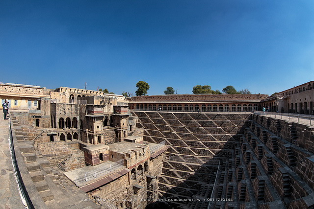
<p>Most people who see photos of Chand Baori for the first time assume it’s been digitally altered. The dizzying pattern of steps, repeated in flawless symmetry on three sides, looks more like an optical illusion than something built by hand in the 8th or 9th century. Yet it’s very real, and it’s one of the best surviving examples of how ancient Indian communities solved a very practical problem: how to store and access water in a region where it was scarce for most of the year.</p>

<p>This guide covers everything worth knowing about Chand Baori, its history, architecture, and why it’s earned a spot on so many travel bucket lists in recent years, along with practical visiting information and insights that are useful whether you’re a curious traveler, a history enthusiast, or a local business owner in the Abhaneri or Jaipur region looking to understand this heritage site’s growing tourism value.</p>

<div class="video-embed">
  <iframe width="560" height="315" src="https://www.youtube.com/embed/h5DlPzGBnow?si=2grQBtCD8LlhWRuv&amp;start=930" title="YouTube video player" frameborder="0" allow="accelerometer; autoplay; clipboard-write; encrypted-media; gyroscope; picture-in-picture; web-share" referrerpolicy="strict-origin-when-cross-origin" allowfullscreen=""></iframe>
</div>

<h2 id="quick-facts-about-chand-baori">Quick Facts About Chand Baori</h2>

<table>
  <thead>
    <tr>
      <th>Feature</th>
      <th>Details</th>
    </tr>
  </thead>
  <tbody>
    <tr>
      <td>Location</td>
      <td>Abhaneri village, Dausa district, Rajasthan</td>
    </tr>
    <tr>
      <td>Built</td>
      <td>Estimated 8th to 9th century CE</td>
    </tr>
    <tr>
      <td>Built By</td>
      <td>King Chanda of the Nikumbha dynasty</td>
    </tr>
    <tr>
      <td>Depth</td>
      <td>Approximately 30 meters (about 100 feet)</td>
    </tr>
    <tr>
      <td>Number of Steps</td>
      <td>Around 3,500 steps across 13 levels</td>
    </tr>
    <tr>
      <td>Structure Type</td>
      <td>Stepwell (Baori/Baoli)</td>
    </tr>
    <tr>
      <td>Nearest City</td>
      <td>Jaipur, about 95 km away</td>
    </tr>
    <tr>
      <td>Best Time to Visit</td>
      <td>October to March</td>
    </tr>
    <tr>
      <td>Entry Fee</td>
      <td>Nominal fee for Indian and foreign nationals (varies, check current ASI rates)</td>
    </tr>
    <tr>
      <td>Managed By</td>
      <td>Archaeological Survey of India (ASI)</td>
    </tr>
  </tbody>
</table>

<h2 id="what-exactly-is-a-stepwell-and-why-does-chand-baori-matter">What Exactly Is a Stepwell, and Why Does Chand Baori Matter?</h2>

<p>Stepwells, known locally as baoris or baolis, were a practical response to a genuine problem across arid parts of India, especially Rajasthan and Gujarat. Groundwater levels would drop significantly during dry months, so communities built deep wells with stepped sides, allowing people to walk down to whatever water level was available rather than relying solely on ropes and buckets.</p>

<p>Chand Baori stands out because of its scale and precision. Unlike simpler wells, it was designed as both a functional water source and a community gathering space, cool even during Rajasthan’s punishing summers thanks to the temperature difference between the surface and the deeper levels. Historians estimate the temperature at the bottom can be several degrees cooler than at ground level, which made it a practical retreat during hot afternoons, not just a water source.</p>

<p>It’s also one of the largest and deepest stepwells in India, which is part of why it draws so much attention from architects, historians, and photographers from around the world.</p>

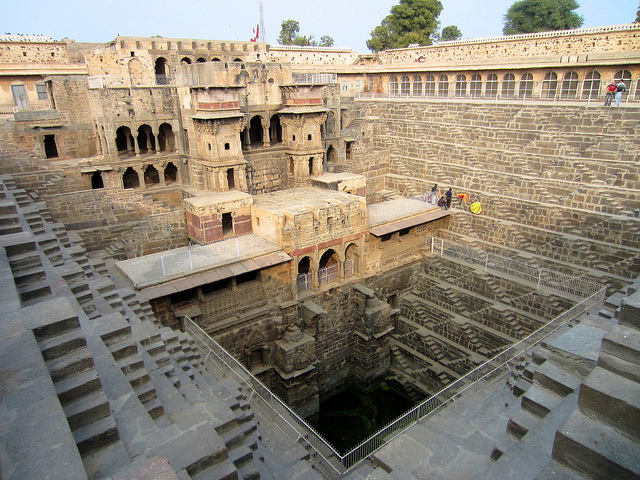
<p><img src="https://www.chandbaori.org/images/Chand-Baori.jpg" alt="Chand Baori's towering stepped walls at Abhaneri, Rajasthan" loading="lazy" decoding="async" /></p>

<h3 id="the-story-behind-its-construction">The Story Behind Its Construction</h3>

<p>Chand Baori is believed to have been commissioned by King Chanda, a ruler from the Nikumbha dynasty, sometime between the 8th and 9th centuries. The well was built adjacent to a temple dedicated to Harshat Mata, the goddess of joy and happiness, and the two structures together formed an important religious and social center for the region.</p>

<p>Over centuries, parts of the surrounding complex were modified, including additions during later periods that introduced pavilions and rooms along one side of the well, believed to have been used by royal family members. This blend of utilitarian design and architectural ornamentation is part of what makes Chand Baori historically significant beyond just its size. For a deeper dive into the archaeological record, see the <a href="https://en.wikipedia.org/wiki/Chand_Baori">Wikipedia article on Chand Baori</a>.</p>

<h2 id="the-architecture-that-makes-chand-baori-famous">The Architecture That Makes Chand Baori Famous</h2>

<h3 id="geometric-precision-without-modern-tools">Geometric Precision Without Modern Tools</h3>

<p>What continues to amaze engineers and architects today is that Chand Baori’s stepped walls were constructed with such mathematical precision using tools and techniques available more than a thousand years ago. The steps form a repeating zigzag pattern on three sides of the well, creating a visual effect that shifts depending on the angle and time of day.</p>

<p><img src="https://upload.wikimedia.org/wikipedia/commons/thumb/3/35/Chand_Baori_perspective_panorama_%28July_2022%29.jpg/960px-Chand_Baori_perspective_panorama_%28July_2022%29.jpg?utm_source=en.wikipedia.org&amp;utm_campaign=parser&amp;utm_content=thumbnail" alt="Panoramic view of Chand Baori's geometric step arrangement" loading="lazy" decoding="async" /></p>

<h3 id="the-fourth-side">The Fourth Side</h3>

<p>Unlike the other three sides, the fourth side of Chand Baori features a multi-story structure with covered verandas, chambers, and carved pillars. This section was reportedly used as a resting place for royalty and offered a shaded, more comfortable space compared to the exposed stepped sides.</p>

<p><img src="https://www.chandbaori.org/images/Chand_Baori_inside-view.jpg" alt="The covered verandas and chambers on the fourth side of Chand Baori" loading="lazy" decoding="async" /></p>

<h3 id="symbolism-and-design-philosophy">Symbolism and Design Philosophy</h3>

<p>Some historians and architects have pointed out that the well’s design reflects deeper cultural ideas about descending into the earth as a symbolic journey, connecting the physical act of reaching water with spiritual or reflective practices common in ancient Indian architecture. Whether or not that symbolism was intentional, it adds another layer of interest for visitors and researchers studying vernacular Indian architecture.</p>

<h2 id="why-chand-baori-has-become-a-global-attraction">Why Chand Baori Has Become a Global Attraction</h2>

<p>While Chand Baori has existed for over a thousand years, its popularity as a tourist destination has grown significantly in the last two decades, partly due to its appearance in international films and increased visibility on social media and travel photography platforms. Its dramatic, almost surreal geometry photographs exceptionally well, which has made it a favorite subject for architecture photographers and travel influencers.</p>

<p>This surge in visibility has had a real economic impact on the surrounding region. Abhaneri, once a relatively quiet village, now sees a steady flow of domestic and international visitors, creating opportunities for local guides, small vendors, homestays, and transport operators.</p>

<h3 id="a-few-notable-points">A Few Notable Points</h3>

<ul>
  <li>Chand Baori is considered one of the largest stepwells in the world by depth and step count.</li>
  <li>It’s protected and maintained by the Archaeological Survey of India, which limits public access to the lower steps for preservation and safety reasons.</li>
  <li>The site is often mentioned alongside other famous Rajasthan stepwells like Rani ki Vav in Gujarat, though Chand Baori predates many of its well-known counterparts.</li>
</ul>

<h2 id="best-time-to-visit-chand-baori">Best Time to Visit Chand Baori</h2>

<h3 id="october-to-march-recommended">October to March (Recommended)</h3>

<p>This is the most comfortable period to visit, with cooler daytime temperatures making it easier to explore the site and the surrounding village without the intense heat Rajasthan is known for.</p>

<h3 id="april-to-june-summer">April to June (Summer)</h3>

<p>Temperatures can climb well above 40°C in this region during peak summer, so visits during these months should be planned for early morning to avoid the harshest heat.</p>

<h3 id="july-to-september-monsoon">July to September (Monsoon)</h3>

<p>Rainfall can add a different visual character to the site, though travel logistics in rural Rajasthan can be less predictable during this period.</p>

<h2 id="how-to-reach-chand-baori">How to Reach Chand Baori</h2>

<p><strong>By Air:</strong> The nearest airport is Jaipur International Airport, roughly 95 km from Abhaneri.</p>

<p><strong>By Rail:</strong> Jaipur Junction is the closest major railway station, well connected to most parts of the country.</p>

<p><strong>By Road:</strong> Chand Baori is often visited as part of a day trip from Jaipur, combined with nearby attractions like Abhaneri’s Harshat Mata Temple. The drive typically takes around 2 hours depending on traffic and road conditions.</p>

<p>For the latest visitor updates and official details, see the <a href="http://www.chandbaori.org/">official Chand Baori website</a>, or <a href="https://mapy.com/en/?source=osm&amp;id=150437719">view the site’s exact location on a map</a>.</p>

<p>Looking for more heritage stops near Jaipur or across India? <a href="/BharatByDay/search/">Search every gem we’ve covered</a> or browse the <a href="/BharatByDay/archive.html">full daily archive</a>.</p>

<h2 id="practical-tips-for-visitors">Practical Tips for Visitors</h2>

<ol>
  <li><strong>Visit early in the day.</strong> Mornings offer softer light for photography and cooler temperatures for walking around the site.</li>
  <li><strong>Hire a local guide if possible.</strong> Much of the well’s history isn’t fully covered on standard signage, and a knowledgeable guide can add real depth to the visit.</li>
  <li><strong>Respect the barriers.</strong> Public access to the stepwell itself is restricted to the upper viewing areas for safety and preservation, so avoid attempting to go past marked boundaries.</li>
  <li><strong>Combine it with nearby sites.</strong> Pairing Chand Baori with the Harshat Mata Temple and other nearby heritage stops makes for a more complete day trip from Jaipur.</li>
  <li><strong>Carry water and sun protection.</strong> Even in cooler months, the open courtyard area offers little shade during midday hours.</li>
</ol>

<h2 id="what-this-means-for-local-businesses-and-entrepreneurs">What This Means for Local Businesses and Entrepreneurs</h2>

<p>Heritage tourism sites like Chand Baori don’t just benefit large travel companies. They create real, tangible opportunities for small and local businesses, homestays, tour guides, artisans selling local crafts, and transport services operating in and around Abhaneri and the broader Dausa district.</p>

<p>As more travelers plan trips using search engines and AI-powered travel assistants, the businesses that show up in those results are often the ones that get booked. This makes a strong, accurate online presence genuinely important, not just a nice-to-have.</p>

<h3 id="actionable-steps-for-local-businesses-near-heritage-sites">Actionable Steps for Local Businesses Near Heritage Sites</h3>

<ul>
  <li><strong>Keep your Google Business Profile current.</strong> Accurate hours, updated photos, and correct contact information matter more than people realize, especially for travelers making last-minute decisions.</li>
  <li><strong>Use specific, relevant keywords.</strong> Phrases like “Chand Baori guide,” “Abhaneri homestay,” or “Jaipur day trip stepwell” reflect how real travelers search.</li>
  <li><strong>Encourage and respond to reviews.</strong> Reviews influence both traveler decisions and how AI search tools evaluate and summarize business credibility.</li>
  <li><strong>Build a simple, fast, mobile-friendly website.</strong> Many travelers research and book on their phones while planning trips, sometimes with limited connectivity in rural areas, so speed and simplicity matter.</li>
  <li><strong>Tell your story clearly.</strong> Whether you’re a guide, homestay owner, or craft seller, a clear description of what you offer helps both human visitors and AI tools understand and recommend your business accurately.</li>
</ul>

<h2 id="key-takeaways">Key Takeaways</h2>

<ul>
  <li>Chand Baori is one of India’s oldest and deepest stepwells, believed to have been built in the 8th or 9th century by King Chanda.</li>
  <li>The stepwell descends roughly 30 meters with around 3,500 steps arranged in striking geometric symmetry.</li>
  <li>It served both a practical purpose, water storage and access, and a social one, offering a cool retreat during hot months.</li>
  <li>The site is protected by the Archaeological Survey of India, and public access to the lower steps is restricted.</li>
  <li>Growing global visibility has turned Chand Baori into a meaningful driver of local tourism and small business opportunity in the Abhaneri region.</li>
  <li>A strong digital presence has become essential for local businesses looking to benefit from this growing tourist interest.</li>
</ul>

<h2 id="frequently-asked-questions">Frequently Asked Questions</h2>

<p><strong>Q1: What is Chand Baori famous for?</strong>
Chand Baori is famous for being one of the largest and deepest stepwells in India, featuring roughly 3,500 steps arranged in a striking geometric pattern across 13 levels, built more than a thousand years ago without modern construction tools.</p>

<p><strong>Q2: Where is Chand Baori located?</strong>
Chand Baori is located in the village of Abhaneri, in the Dausa district of Rajasthan, about 95 km from Jaipur.</p>

<p><strong>Q3: Who built Chand Baori and when?</strong>
Chand Baori is believed to have been built by King Chanda of the Nikumbha dynasty, sometime between the 8th and 9th centuries CE.</p>

<p><strong>Q4: Can visitors walk down the steps of Chand Baori?</strong>
No, public access to the stepwell itself is restricted for safety and preservation reasons. Visitors can view the structure from designated viewing areas around the upper level.</p>

<p><strong>Q5: How deep is Chand Baori?</strong>
Chand Baori is approximately 30 meters, or about 100 feet, deep.</p>

<p><strong>Q6: What is the best time to visit Chand Baori?</strong>
The best time to visit is between October and March, when temperatures are cooler and more comfortable for exploring the site and surrounding village.</p>

<h2 id="conclusion">Conclusion</h2>

<p>Chand Baori is proof that some of the most impressive engineering achievements don’t need modern technology to leave people in awe centuries later. It’s a site that rewards curiosity, whether you’re interested in ancient architecture, water conservation history, or simply want to see something that genuinely looks unlike anything else in the world.</p>

<p>Craving more hidden India? Keep exploring with our guides to the <a href="/BharatByDay/2026/08/02/dzuko-valley-the-flower-meadow.html">Dzüko Valley flower meadows in Nagaland</a> and <a href="/BharatByDay/chikmagalur-coffee-land-karnataka-guide">Chikmagalur, Karnataka’s coffee country</a>.</p>

<p>For the local businesses and communities around Abhaneri, sites like Chand Baori represent a real and growing opportunity. But turning tourist interest into consistent bookings and revenue takes more than just proximity to a famous landmark. It takes a clear, trustworthy digital presence that helps travelers find and trust your business before they ever arrive. That’s an area where teams like <strong><a href="https://f9xr.github.io/pages/services.html">F9XR</a></strong> support local and regional businesses, offering <a href="https://f9xr.github.io/tools/website-cost.html">website development</a>, website redesign, <a href="https://f9xr.github.io/tools/local-seo-score.html">local SEO</a>, and broader digital presence solutions that help heritage-adjacent businesses turn visibility into real growth.</p>

<script type="application/ld+json">
{
  "@context": "https://schema.org",
  "@type": "FAQPage",
  "mainEntity": [
    {
      "@type": "Question",
      "name": "What is Chand Baori famous for?",
      "acceptedAnswer": {
        "@type": "Answer",
        "text": "Chand Baori is famous for being one of the largest and deepest stepwells in India, featuring roughly 3,500 steps arranged in a striking geometric pattern across 13 levels, built more than a thousand years ago without modern construction tools."
      }
    },
    {
      "@type": "Question",
      "name": "Where is Chand Baori located?",
      "acceptedAnswer": {
        "@type": "Answer",
        "text": "Chand Baori is located in the village of Abhaneri, in the Dausa district of Rajasthan, about 95 km from Jaipur."
      }
    },
    {
      "@type": "Question",
      "name": "Who built Chand Baori and when?",
      "acceptedAnswer": {
        "@type": "Answer",
        "text": "Chand Baori is believed to have been built by King Chanda of the Nikumbha dynasty, sometime between the 8th and 9th centuries CE."
      }
    },
    {
      "@type": "Question",
      "name": "Can visitors walk down the steps of Chand Baori?",
      "acceptedAnswer": {
        "@type": "Answer",
        "text": "No, public access to the stepwell itself is restricted for safety and preservation reasons. Visitors can view the structure from designated viewing areas around the upper level."
      }
    },
    {
      "@type": "Question",
      "name": "How deep is Chand Baori?",
      "acceptedAnswer": {
        "@type": "Answer",
        "text": "Chand Baori is approximately 30 meters, or about 100 feet, deep."
      }
    },
    {
      "@type": "Question",
      "name": "What is the best time to visit Chand Baori?",
      "acceptedAnswer": {
        "@type": "Answer",
        "text": "The best time to visit is between October and March, when temperatures are cooler and more comfortable for exploring the site and surrounding village."
      }
    }
  ]
}
</script>]]></content><author><name>F9XR Editorial Team</name></author><category term="Rajasthan" /><category term="Abhaneri Rajasthan" /><category term="Indian Stepwells" /><category term="Rajasthan Tourism" /><category term="Ancient Indian Architecture" /><category term="Heritage Sites India" /><category term="Jaipur Day Trips" /><category term="Nikumbha Dynasty" /><category term="Archaeological Survey of India" /><category term="Local SEO for Tourism Businesses" /><summary type="html"><![CDATA[Explore Chand Baori, one of India's deepest stepwells in Abhaneri, Rajasthan. History, architecture, visiting tips, and why it still amazes travelers.]]></summary><media:thumbnail xmlns:media="http://search.yahoo.com/mrss/" url="https://www.chandbaori.org/images/Chand-Baori-banner.png" /><media:content medium="image" url="https://www.chandbaori.org/images/Chand-Baori-banner.png" xmlns:media="http://search.yahoo.com/mrss/" /></entry></feed>